Death penalty in the US Flight seats booking Theater reservations
Housing scheme estate Shipyard planning occupency
All these examples can be done with the FREE version of BeGraphic
that you can download on the page "Download / Lite version".
Death penalty in the US
![]()
![]()
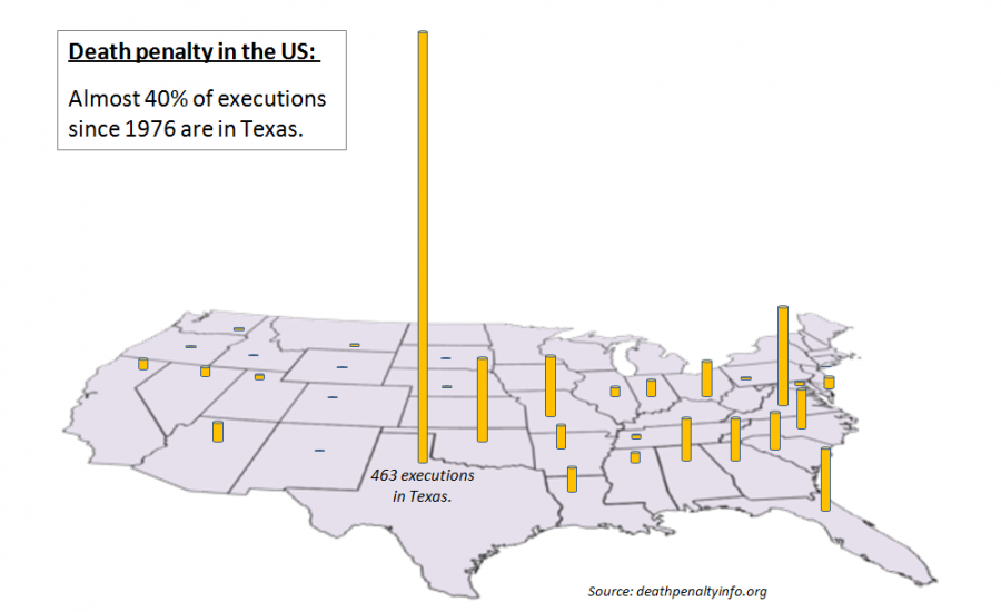
A picture is worth a thousands words!
Charts and graphics show trends and exceptions at one glance.
custom map in excel, live data maps, tinted map, dynamic colored map, dynamic color-coding diagram, One look is worth a thousand words, The drawing shows me at one glance what might be spread over ten pages in a book, Every picture tells a story, Use a picture. It's worth a thousand words, digital hegemony, visual messages have reasserted their position as an important communication medium, pictures as vital in communication, free clipart map, free cliparts USA, free clip art maps, wmf clip art geographical map, emf clipart maps of australia and new zealand, custom graphic, be graphic, map graphics, free custom maps, open and free world atlas, .
Flight seats booking
![]()
![]()
![]()
![]()

With BeGraphic, you can visualize what you want for your business. Here is an example of a flight seats booking system. Seats Colors change automatically depending on cells values. Now, you can easily have an insight about the plane occupency. BeGraphic works with all WMF, photos and PowerPoint Clip Arts. Interactive maps give you the opportunity to have professional-looking presentations.
e.g.: custom map in powerpoint, dynamic color-coding diagram, seats booking system, data-driven maps in PowerPoint and excel spreadsheet, editable map, free clipart map, free map in PowerPoint, map at zero cost for Microsoft Office, free USA map, free australia map, free new zealand map, free UK map, free germany map, gratuitous map for powerpoint, open source dynamic map, free PowerPoint maps, PowerPoint Templates plans, download PowerPoint free maps, ppt templates, download editable maps for presentations, country clickable map, countries, federal, state, province, county, counties, territories, area, part, sectors, borders, boundaries, ambit, editable, administrative, districts, cities, your, locations, headquarters, sales, local, planning, analyses, with, these, digital, maps, powerpoint, template, business map, marketing map for powerpoint, free maps for presentations, free powerpoint map, ppt free - map, powerpoint map, free clipart, microsoft clipart, clip arts, using maps in PowerPoint, free powerpoint templates, free vector & bump maps, insert a map in powerpoint, free presentations in PowerPoint format for Themes of Geography, Maps and Map Skills, Landforms including Coasts, Deserts, Islands,World of Maps Clip Art collection of royalty free editable PowerPoint and Illustrator maps. Large collection of World, US, State, County, World Regions, create a custom road or metro map in Visio and copy and paste it into PowerPoint, a world atlas of facts flags and maps and free clip art every continent, country, dependency, custom maps Commercial & Corporate PowerPoint, PowerPoint Templates, ppt free - maps for presentations.
Theater seats reservation
![]()
![]()
![]()
 |
Picadilly Theater of London
Seats booking
Here is an example of the prestigious Picadilly Theater of London. Red squares represent booked seats. Now you adjust price of tickets according to your yield management policy.
It's also working with concert and conference room plans. |
e.g.: theater seats booking system, custom map, edit free map for powerpoint, seats reservations, Picadilly theater of London, dynamic map, data-driven graphic, infographics, innovative dashboard in Excel, Editable Digital Maps, Vector, PowerPoint Maps, Illustrator, Flash, Editable PowerPoint Maps, Digital Vector Maps, Illustrator Maps, Flash Maps, PDF Maps, PowerPoint Templates and other Presentation Solutions - Digital Vector Maps, Editable USA maps, Downloadable Maps, State Vector Maps for PowerPoint Presentations, Web Development maps, free desktop publishing maps, Illustrator Maps, Flash Maps, PowerPoint Presentations PPT Templates USA Maps, US State Maps, State Map, Digital State Maps, US Counties, PowerPoint Maps, Editable Presentation Maps, push pin PowerPoint maps are a great new addition to our free downloadable templates selection. These are maps of individual countries, Free editable PowerPoint maps of North and Central America. Here you will find the latest editions to our editable Vector PowerPoint map range. These maps are made for microsoft office, Looking for editable PowerPoint maps? Instantly download United States, India and other countries around the world in PowerPoint format, the largest collection of royalty-free digital vector maps, interactive flash maps, PowerPoint geographical maps and plans, World map PowerPoint template shows a map of the world over a gradient color.
Housing Scheme Estate
![]()
![]()
![]()
|
|
Housing Scheme Estate
This housing scheme estate example is dynamic: colors of land areas change automatically according to their status. Green if the parcel is for sale, orange for preemted and red for sold.
BeGraphic is easy-to-handle and it gives you the possibility to create innovative presentations. |

e.g.: real estate planification, neigborhood occupency, custom map, edit free maps, editable clipart maps, housing scheme, housing estate, dynamic diagram, infographics, choropleth map in PowerPoint, data-driven shape in PowerPoint and Excel, Illustrator Maps, Flash Maps, PowerPoint Presentations PPT Templates USA Maps, US State Maps, State Map, Digital State Maps, US Counties, PowerPoint Maps, Editable Presentation Maps, free digital vector maps, interactive flash maps, free united states maps, illustrator maps, editable digital maps vector powerpoint maps illustrator flash, congressional maps, flash maps, map wizard, continents, powerpoint templates, powerpoint maps,world maps, editable digital maps vector powerpoint maps illustrator flash, royalty-free digital maps, digital map collections, powerpoint backgrounds, powerpoint graphics, country maps, clickable united states maps, state maps digital vector powerpoint flash and illustrator format, clickable website maps, city county databases, powerpoint map collection, maps for powerpoint, pdf maps, more than free sample, our maps library is free, download free sphere powerpoint templates and backgrounds for powerpoint presentations, free World, Map, Geography, Globe, Countries, Continents, Earth maps in Excel spreadsheet an PowerPoint presentation tool, Editable Vector USA Map, USA State, Europe, World Maps for PowerPoint Presentations, Illustrator, web site maps, Download to Your Computer, Editable Outline, Free PowerPoint templates and Free PowerPoint backgrounds for presentations ready to use, High-quality editable maps of the United States of America with states for your PowerPoint presentations, You can get the free US ppt that available for you to edit. Not only Powerpoint USA map, you can also choose editable maps of Canada, India, Australia, New Zealand and hundreds of other countries, This section lists free presentations in PowerPoint format for Geography, Maps and Map Skills, Landforms including Coasts, Lakes, Deserts, Islands, Mountains, Plains, Oceans, Rivers, plus Regions of the World, Communities, Continents, Countries & counties.
Shipyard planning occupency
![]()
![]()

With BeGraphic, you can make your presentation alive by combining data-driven shapes, gauges and sparklines. In one glance, you can see which buildings are busy or idle, how is the turnover and the occupency in comparison with the past and if the target is reached. You can re-use this presentation idea for factories presentations or theme parks.
e.g.: custom map, edit free map, free clipart map, clip art map, gauges, dashboard, data-driven graphics, building occupency, tachymeters, tachometer, speedometer, gauge chart, odometers, sparklines, line charts, isometric 3D, Illustrator Maps, Flash Maps, PowerPoint Presentations PPT Templates USA Maps, US State Maps, State Map, Digital State Maps, US Counties, PowerPoint Maps, Editable Presentation Maps, Editable PowerPoint Maps, Digital Vector Maps, Illustrator Maps, Flash Maps, PDF Maps, PowerPoint Templates and other Presentation Solutions - Digital Vector Maps, Editable USA maps, Downloadable Maps, State Vector Maps for PowerPoint Presentations, Web Development, Desktop Publishing, Illustrator, Editable Digital Maps, Vector, PowerPoint Maps, Illustrator, free Flash maps, interactive flash maps, powerpoint map collection, united states maps, powerpoint templates, flash maps, new jersey state maps, nebraska state maps, digital vector maps, world map in Powerpoint, earth map in excel, europe free map, india editable map in powerpoint, country maps, powerpoint maps, colorado state maps, north america, mississippi state maps, congressional maps, ireland map, south carolina state map, canada editable map, south dakota state maps africa map, maine state map, scotland editable map, florida state map, wyoming state map, israel editable map, asia map, portugal map, michigan state map, graphic resources maps, editable digital maps vector powerpoint maps illustrator flash, south africa map, usa editable map, connecticut state map for powerpoint, mexico free map, northern ireland, denmark free map, clickable united states maps, austria editable map, download free powerpoint template backgrounds, minnesota state maps, europe free map, pennsylvania state maps, russia free map, india free map, turkey editable map, australia free map, italy free map, spain free map, texas state maps, louisiana state maps, new mexico state maps, virginia state maps, ohio state maps, powerpoint backgrounds, norway free map, germany free map, continent editable maps, maps for powerpoint, free maps for powerpoint, belgium map for powerpoint, us maps, maine state map, scotland editable map, florida state map, wyoming state map, israel editable map, asia map, portugal map, michigan state map, graphic resources maps, editable digital maps vector powerpoint maps illustrator flash, south africa map, usa editable map, connecticut state map for powerpoint, state maps digital vector powerpoint flash and illustrator format, idaho state maps, washington state maps, utah state maps, japan editable map, rhode island state maps, arkansas state maps, oklahoma state maps, venezuela, taiwan, georgia state maps, massachusetts state maps, france editable map, argentina free map, all u.s 50 individual state flash maps, greece free map, poland free map, virgin island free maps, alaska state maps, alabama state maps, finland free map, free map downloads, download free powerpoint template backgrounds,saudia arabia free map, minnesota state maps, europe free map, pennsylvania state maps, russia free map, india free map, turkey editable map, australia free map, italy free map, spain free map, texas state maps, louisiana state maps, new mexico state maps, virginia state maps, ohio state maps, powerpoint backgrounds, norway free map, germany free map, continent editable maps, maps for powerpoint, free maps for powerpoint, belgium map for powerpoint, us maps, editable indiana state maps, lebanon free map, new zealand free map, free website maps, brazil map for powerpoint, england free map, pakistan free map, north dakota state maps, puerto rico free maps, north korea free map, tennessee state maps for powerpoint, illinois state maps, digital map collections, wisconsin state maps, california state free maps, new york state maps, free map collection, missouri state maps, vermont state maps, clickable website maps, clikable free map for powerpoint, netherlands free map, iraq editable map, china free map for powerpoint, cuba editable map, south america free map, nevada state maps, iran free map, new hampshire state maps, powerpoint graphics, switzerland free map, indonesia free map, egypt map for powerpoint, kentucky state maps, south korea free map, arizona state maps, iowa state maps, city county list, afghanistan free map, west virginia state maps, continents free map for powerpoint, kansas state maps, delaware state map, montana state maps, maryland state maps, us state maps, available interactive flash maps, city county databases, hawaii state maps, Feel free to copy the autoshapes and freeform formats, Find fully editable, digital maps of the World & Globe in PowerPoint (PPT) Format from the largest Map collection for PowerPoint and Excel, Royalty Free Vector Maps in Adobe Illustrator and PDF Format to use with Excel spreadsheet and PowerPoint, Detailed maps for PowerPoint, easily edited, adjusted, scaled and colored. Maps & Flags, More than 1000 templates, designs and slides as a free download, globe, earth, global, sphere, map, world map, planet, world, world wide, blue, free powerpoint templates, Downloadable, Royalty Free, Editable, Digital Maps for PowerPoint. ... PowerPoint maps are completely editable for sales and marketing presentations. Death penalty in the US: number of executions since 1976.